Monday, October 14, 2013

Tripp'n on the AT

The highlight of this trip is what Star refers to as "The Show."  Our last night on Standing Indian Mountain at 5,247 ft. in the Southern Nantahala Forest, we were treated to a two hour sunset extravaganza the likes of which neither of us has ever seen.  It was made more memorable by the several campers visiting our site from down below who stayed with us until sunset.  A special congratulations to "Righteous", who spent the evening at our campsite until bedtime.  He was on his 138th day of the AT with a just few days to go until completion, and spent the evening sharing tales of his adventures with us.

Believe it or not, here go the untouched photos of "The Show."


Sunday, August 11, 2013

The Washington State Postgame Show

We arrived home early Thursday morning just after midnight, and for the first time in 18 days we had internet service fast enough to download some ridiculous videos from our trip.  Actually, we have combined some video clips into short movies for these.

Surviving a night on the Skyline Divide
with a little help from "our friend"
 
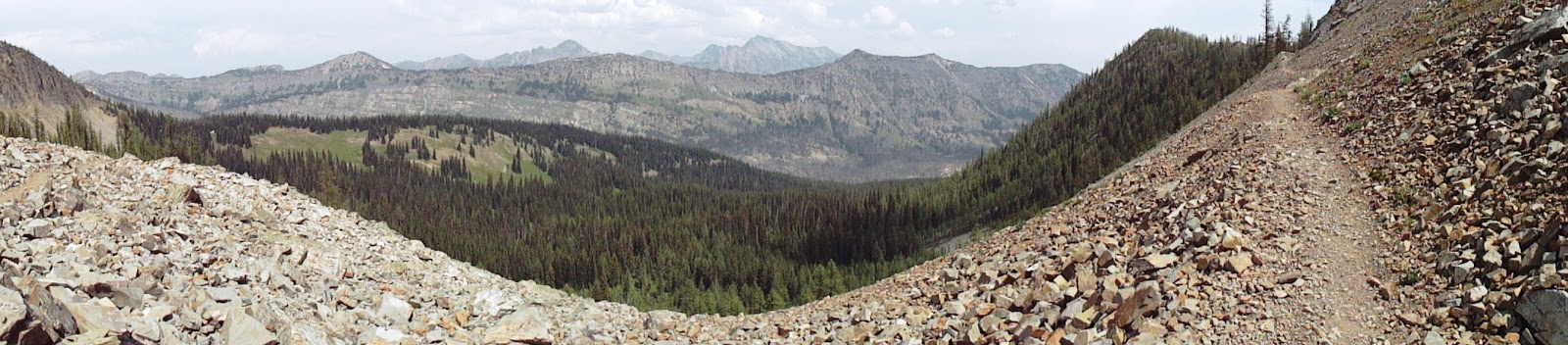
Day hikes don't get much tougher, or more beautiful,
than Maple Pass Loop, which actually crosses
three passes
 
Star calls it the Pacific Coast Trail, but then again, she calls Revco Pharmacy "CVS."
After driving 19 miles on a rock and gravel road from the nearest store,
you are in deep wilderness at the trailhead.  We have now backpacked
 on the PCT in both California and Washington.
 
 
Some Miscellaneous Photos
 
               Ptarmigan Ridge Snow Patterns

We ate at Graham's Store twice, where you can
"Dine in simulated luxury underneath the 
Willow Tree in the backyard"         

    Spent our first few days at Mt. Baker in this
    wonderful custom cabin by the Nooksack River
                            Thanks, John!


Our Final Thoughts
 
Despite my ad nauseam postings filled with photos and videos of hiking trips, Star and I have been discussing how the people we encountered were the most fascinating part of this trip.  Every summer, we go west to hike and backpack, but travelling in Washington State this particular summer we met people on much bigger, tougher, and grander adventures.  We met people who inspire, provoke, and challenge our way of doing things, and people who are kind, thoughtful, and more than willing to lend a hand or reach out for one.  May each of you be blessed in your journeys thru life.
 
Ben 
 

Tripping, 2013

We were aliens, easily

ID’d by our foreign accents

even though we disguised

our big ears and furry toes

with traditional hiking garb.

 
There were others, of course

like the elderly blind man from

Massachusetts on a snow-covered trail. 

He was so terrified of heights

he couldn’t see that he trekked

with tears running down his face.  

And the tripper from Arizona whose

companion waited patiently for breakfast

leftovers in his covered doggie

carrier on the bicycle. 

 
The natives were friendly, even the

Boy Scouts who invited us to share

their camping spot.  For privacy, we

ignored the storm and found another

half an hour down the trail, marked HERE

in the dust by a couple from the parking lot.
 

Once in a while, we met someone

who knew we weren’t exactly from the

planet where Deliverance was filmed.

One even had hiked along the Chattooga

although he had shared it with copperheads

and dangerous denizens in overalls.
 

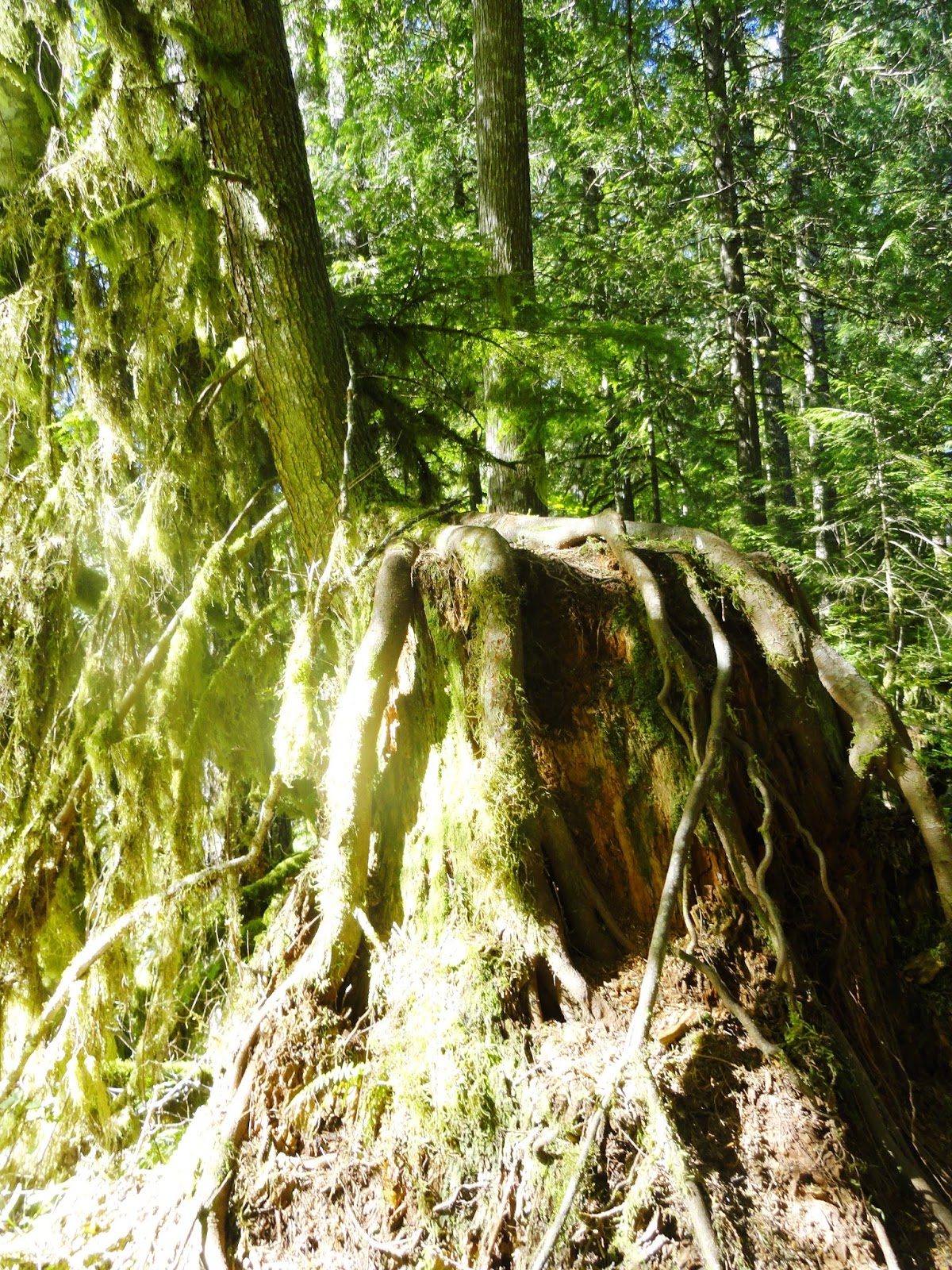
Thanks to the gremlin in Graham’s who sent us

to the village of trees at exit 42, older than anything

created outside of nature and the real giants of Washington. 

Thanks to JaNae, with her children as illegal as ours

Marta and a sliver of minke whale we chased

through the Salish Sea, and a friendly hitchhiker. 

A final thanks and sigh of relief for divine intervention

which led us to Ben’s wallet under our car seat and

the computer almost turned in with the rental pod.

 
And so we’re back in home territory, happy to

find it just as strange and wonderful as any trip.
 
Star


Tuesday, August 6, 2013

Doe Bay, Orcas Island

We are chilling our last 5 days in Washington State on the remote island of Orcas in the even more remote Doe Bay.  The food is fantastic.  The spa is eclectic.  The views are mind blowing.  The atmosphere is unlike anything east of the Mississippi. 

Doe Bay


Campy

The General Store and CafĂ© 

On Monday, August 5th, we took a whale watching excursion from Orcas to Canadian waters.  We didn’t see any Orcas on this day, but we did see a Minke Whale and a lot of other wildlife.  Heck, it was worth the money just to get out on the water.

Bald Eagle from the boat
 
Hmm, I'm pretty certain this is illegal in South Carolina
 
Our naturalist said this Minke Whale was between 35 and 40 ft. 
If I had to make a living as a wildlife photographer,
I'd go hungry.
 
The Salish Sea
Star got sick from me humming the theme to Gilligan's Island.
I thought everybody loved that song :-)
 
 We started this trip as a vacation, but it really has turned into our biggest adventure to date.  Four nights out in a tent, 8 days of tough deep wilderness hiking in 10 days, at least 7,500 ft. of elevation, and perhaps biggest of all, the logistics of packing and moving from one location to another multiple times.
 
When we get better internet service in a couple of days, we'll post a few humorous videos of us facing unnecessary risks and dangers.


Saturday, August 3, 2013

Backpacking to Grasshopper Pass in the Okanogan National Forest


 Snowy Lakes or Grasshopper Pass was our dilemma for our final backpacking venture.  After consulting with a few locals, we opted for the latter.  It turned out to be an excellent choice.

First, the road to Harts Pass and the trailhead had to be navigated in our little Yaris rental car.  This 10 mile, mostly one lane, gravel and rock road carved into the side of a cliff takes you to the highest point of any road in Washington State at nearly 6,000 ft.  I was driving and Star couldn’t bring herself to take pictures (Plus, she was watching for large rocks scattered along the road), so you will need to search the internet for photos of this engineering feat of the ludicrous.  At one place called Dead Horse Point, you are literally suspended on the edge of a vertical rock face for 0.5 miles praying to every god imaginable that another vehicle doesn’t come from the opposite direction.  To make matters worse, a huge tree had fallen across the road and the Forest Service literally cut out a section of it just before our arrival.  They were directing traffic through a “slot” as we came by.

Anyway, we made it to the trailhead for the Pacific Crest Trail before noon and were on our way.  Once again, we found ourselves hiking along a stretch of trail with full exposure across scree slopes.  In fact, the entire 5 miles of the PCT to Grasshopper Pass traversed the steep sides of high ridges, where you could see the trail laid out almost in its entirety ahead of us.

 A nice gentleman had stopped us on the trail, and told us where the nicest camp spot was in the area. In fact, he had it marked with 3 sticks forming an arrow.  As we reached the site, a thunderstorm overtook us.  We were able to get the tent up as the harder rain started to fall.  When it stopped, we had dinner and drinks (vodka and cranberry :-). 

I'll shut up and let the pictures do the talking.

The Trailhead

Traversing one of many scree slopes
 
Tatie Peak

View from our tent.  Nice front yard!

Just before breaking camp
 

Wednesday, July 31, 2013

Maple Pass Loop Splendor

Our favorite hike of the trip thus far, this 7 mile 2,000 ft. loop day hike was a fantastic sampling of everything the North Cascades has to offer.  We saw glacial lakes, unfamiliar flowers, fantastic meadows, and big 360 degree views for 5 of the 7 miles.  From Maple Pass, we could see legendary Glacier Peak and even Mount Rainer in the distance.

It's difficult to find really good loop trails, and this one is a gem.

We started at 4,900 feet, and climbed steadily for 4 miles traversing two mountain passes.  And when we finally reached our high point on a flank of Frisco Mountain (6,900'), we started a bone jarring 2,000 ft. descent in 2 miles winding our way along a knife’s edge ridge.  It’s another one of those places where you keep thinking to yourself, “I can’t believe I’m actually hiking in such an otherworldly place.”

Although this is one of the most popular trails in Washington State, we ran into very few people.  The ones we did meet, however, were fascinating.  One couple from Tacoma caught up to us at Heather Pass, and hung with us for a while.  They were part of an online group called Pacific Northwest Hikers, and seemed interested in us coming all the way from South Carolina to hike in the North Cascades.  They took several photos of us approaching Maple Pass before parting ways, and the gentleman told us our story and photos would be showing up on their site.

When a second group of 11 hikers later caught up with us, we found out they were from the Northern Applachian Trail Hikers Club.  We think they were mostly from the New England area, and were extremely friendly and curious about our adventures.  One of them asked about the debacle known as South Carolina politics and our history of unscrupulous politicians.  We politely declined to participate in that discussion.

In the right circumstances, social interaction on the trail can be one of the most rewarding parts of hiking.  I still say you can have more open, direct, conversation with people on the trail than you will ever have in a church, bar, or most any other place on this planet.
 
We are checking out of the quaint, peaceful Freestone Inn today, and headed out for one last overnight backpacking trip in the North Cascades before heading back west tomorrow afternoon to Orcas Island.  From that point on, there will be no hiking reports, because there will be nothing but R&R for our last 5 days.  To quote a man we passed a few years back hiking in Linville Gorge, "My legs is burning!"


Monday, July 29, 2013

Cascades, Phase Two

For the first time since our departure, I'm going to actually get us up to real time on the blog.  It may not make much sense, since we arrived earlier in Mazama and each of us promptly had four drinks.  Nevertheless, it will be fun for us.

Yesterday, our last at Mt. Baker, we took off on a hike to Hannegan Pass.  The lady at the information desk told us this would not be a good hike, because it was all below the tree line.  We went anyway.  So, really?  You call THIS below tree line?

Ruth Mountain and Hannegan Pass to the left

View from the trail

Mount Sefrit

We ate out our last night in Glacier at Graham's.  Just think of an upscale Esso Club in a town smaller than Central, SC.


This morning we took off from Glacier, Washington to Scenic Highway 20 and the incredibly beautiful North Cascades National Park.  The scenery is jaw dropping, and the crowds similar to a weekend ride up Highway 107 from Walhalla.

So, here we are in the Eastern Mountains of Washington State in a place called Mazama.  Even smaller than Glacier, it is a true gem, with wonderful hospitality.


Diablo Lake, the most beautiful of them all

Washington Pass and Silver Star Mountain
The picture can't do justice to the beauty of this area.
We will be hiking these mountains the next three days.
Unbelievable

A beautiful tribute to Silver Star mounted at Washington Pass
Star insisted we get a photo of this Stafford poem 


Saturday, July 27, 2013

Nooksack River Hike


We just returned to the cabin from a four mile river hike along the Nooksack River called the Horseshoe Bend Trail.  Star says it’s her new favorite river hike, which is a strong statement considering we have hiked the Chattooga, Snake, Elwha, Yellowstone, Saluda, and Teton amongst many others.  The foliage is green like home, but that’s where the similarities end.  Huge ferns,  moss hanging from trees six feet and more in diameter, berries, tiny flowers, and hard woods with leaves bigger than my head crowd the trail.  (That slightly overblown sentence is courtesy of Star.)


The river forms at the Nooksack Glacier 20 or so miles above where we were hiking, and has a hypnotizing blue-green tint.


A tree grows out of the stump of a former Douglas
Fir tree.


I'll buy a beer for the first person to tell me what this is growing from this tree.  A fungus?