Wednesday, May 11, 2016

Bushwhacking the Gila


As always, we had thoroughly researched our route for a 3 day backpacking trip in the Gila Wilderness.  Our plan involved going two miles up the West Fork of the Gila River and then taking Trail 28 (The Zig Zag Trail) to a high plateau between the West Fork and Middle Fork Rivers.  From there we would hike 6 more miles to The Meadows deep in the Gila.  The first 0.5 mile went as planned with two river crossings, but then something unexpected happened-the trail disappeared.


No problems, we knew by following the West Fork River upstream we would eventually intersect Trail 28 and continue on our way.  That’s what our highly detailed $19 topographic trail map clearly showed, so we couldn’t go wrong.

We continued bushwhacking our way up the West Fork River.  Along the way, we found small game trails to move upstream.  Eventually, every one of them ended back at the river, forcing us to make another river crossing to find another path of least resistance.

We continually dodged numerous large ant hills, stepped into deep holes in the sand that looked as though they were home to rattlesnakes, and encountered more than one bear track, and one big cat track (mountain lion).  We were getting scratched and cut by the foliage.  The going was excruciatingly slow and frequently we backtracked to keep going forward. Still, we agreed to continue on, because at 2 miles we would find our Trail 28 as long as we stayed by the river.


Referring to our map frequently to confirm our location, we continued on for another 3 hours.  At one point, we looked up a mountainside and saw what looked like a trail zig zagging up at the approximate location of our Trail 28.  Still, we saw no way to access the potential trail and the bush was way too thick to possibly reach it.  We were not even sure it was a trail, much less the one we needed to find.


At this point, we sat by the river we had now crossed over a dozen times and ate lunch on a rock outcropping.  Based on time and our rate of progress, we figured we had gone at least 3 miles into the wilderness and missed our trail. At this point, we wondered how many actual trails are in the Gila, and how many are just suggested routes marked on a trail map.


Tired, slightly beat up, and humbled by our experience thus far, we decided to backtrack down the river and back to our car.  6 hours later, we returned to the trailhead and our vehicle.  We were completely exhausted, and our boots were swamped from over 20 river crossings.


Even though our backpacking trip fell apart (for only the 3rd time in almost 40 years backpacking), I am so proud of us both.  We never panicked, never lost our cool, and continued to laugh through it all.  Most of all, we knew to stay close to the river.  As long as we did that, we couldn’t get lost.

Instead of driving 90 minutes to the nearest hotel, we decided to car camp at Lake Roberts in the Gila Wilderness, which was the best decision of our trip.  We had expected warm temperatures this time of year deep in the southwest, but it was cold.  In fact, we think the temperatures dropped into the low 30’s overnight.

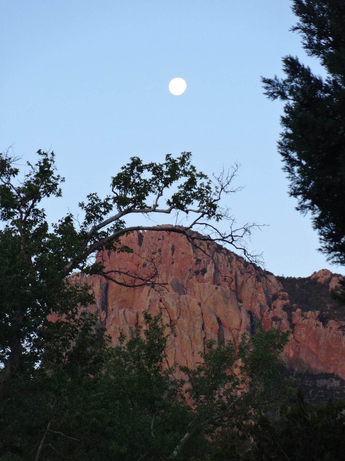
Our campsite was a beautiful location on a high rocky plateau overlooking the undeveloped lake.  Prior to sunset, we were mesmerized by over 20 hawks soaring directly over us for almost two hours.  As the sun set, we watched the hawks depart across the lake directly into the sun, presumably to their home.  It was one of those special moments, and it felt as though the hawks were providing some sort of retribution to Star and me for our earlier misadventures.


Finally, here are some photos from The Buckhorn Saloon and Opera House located in the middle of the woods in Pinos Altos, NM.  I even got on stage and entertained Star for a couple of minutes.


The day before our attempt at backpacking the Gila, we day hiked the Gila Cliff Dwellings. The dwellings range from around 550 AD to 1400 AD.  The earliest Native Americans to call this place home were the Mogollon later followed by the Pueblos.  Unlike many cliff dwellings, you are allowed to enter and walk through the dwellings.


Saturday, April 30, 2016

Saguaro National Park and Chiricahua Wilderness

We are currently at a Comfort Inn in Silver City, NM with actual internet, so it's time to catch up on the happenings of the past week or so.

Prior to leaving Tucson, we did a day hike in West Saguaro National Park, which is Star’s first real hike since her big fall.  It was a huge success.  She not only carried a 15 lb. pack halfway (half of it water) with no problems; she completed 4.8 miles and one thousand feet of elevation up and down.

We started our hike at 7:40 a.m. at a temperature of 68 degrees to try and beat the heat.  The Kings Canyon trail took us high up into the big cactus country to a ridge line. The terrain was completely foreign to us.   Despite many warnings about rattlesnakes, we did not run into any signs of them…thankfully.  Even without water, the hike was fantastic, with many varieties of cacti, including the majestic Saguaro that grows over forty feet high, numerous flowers, and other desert plants.  We probably encountered less than 10 people, but desert sun and empty water bottles sent us back to the car by 11:30 a.m., where it was already 95 degrees.  But hey, it’s a dry heat…right?

Entering West Saguaro National Park

Beginning our Climb

Mt. Wassen, our Destination

Early Spring Flowers, Desert Style

The Largest Cactus We Encountered

Practicing my Self Defense Moves against
Rattlesnakes


One Final Photo from Tucson


Then the road turned and went directly for an immense wall of mountain that looked impossible to drive around.  It had to be a dead end-there could be no opening in that sheer stone obtrusion, that invasion of mountain.  Where the canopy opened, I could see canyon walls of yellow and orange pinnacles and turrets, fluted and twisted, everything rising hundreds of feet.  I couldn’t have been more surprised.  I’d never heard of the Chiricahuas.  I expected nothing.

William Least Heat Moon

We left Tucson on Saturday morning, and headed southeast on I-10 toward the New Mexico Border and the Chiricahua Wilderness.  As we drove, we witnessed one huge dust storm after another.  Luckily, we avoided them all.  At San Simon, Arizona, we took an exit off the interstate, total desert except for rows of fruit trees (not sure what fruit) and a huge mountain range to the south. Following directions for the Cave Creek Ranch, we turned right onto a rough asphalt road, straight as an arrow, that disappeareed into some vanishing point miles ahead.  After 9 miles, the asphalt ended and a dirt/gravel road began, still heading straight south. 


At this point Star took the wheel, and about halfway down the 16 miles of dirt road, the track narrowed and began to climb.  


With Star navigating, we continued to climb gradually until we were surrounded by huge forested mountains with enormous and colorful rock spires in the middle of a flat desert.  As we approached our destination, a huge canyon with tremendously varied rock formations appeared.  I turned to Star and exclaimed, “My God, Star, it looks like Yosemite Valley!”  We later found out the locals call this place “The Yosemite of the Southwest.”  Its official name is Cave Creek Canyon.  And it almost is Yosemite, except it has no crowds, no development, no souvenir shops, only one settlement of around 100 residents, and one general store/restaurant.  


Star hiking up Cave Creek Canyon


6:00 a.m. from our Cabin
We later discovered that Chiricahua Wilderness is a world class birding location.  Although there are almost no hikers here, there are birders from as far away as Canada, and many stay in one of the 11 cabins at Cave Creek Ranch. Our cabin was cozy and private except for frequent visits from the deer, who emptied our bird feeder as often as the birds and squirrels. The area is also home to coyotes, mountain lions, Javelinas, and of course, rattlesnakes. Birders who stay elsewhere pay their $5 and set up on the porch of the office, where you can sometimes smell the resident skunk. 

The photo below may not be the best one ever, but it does catch an Elegant Trogon perched on a tree branch. I'm not a birder, but everyone was really excited about this spotting.


We are in Silver City two more days, and then it's time for our mad three day dash back to South Carolina.  The next blog post will detail our highly adventurous Gila Wilderness backpacking trip, which didn't exactly go as planned.  

Thursday, April 21, 2016

Aloha Maui, Hello Mainland

After spending over two months ridding ourselves of our Maui possessions, dealing with our landlords on getting out of our lease, selling one of two vehicles, shipping our remaining vehicle to San Diego, and finally, cleaning our Maui rental from top to bottom, we have escaped Maui completely exhausted but happy to be returning home.

The flight to San Diego was, thankfully, uneventful.  We arrived at the Best Western Bayside late on Tuesday, which turned out to be an excellent choice for unexpected reasons.  The room was rather basic, but the employees were out of this world with kindness.  As soon as we checked in, they set us up a cab ride for the next morning to an undisclosed location to pick up our Prius.

We mistakenly thought our car would be available for pickup at the docks in San Diego, but the cab driver knew where we needed to go.  We were dropped off 8.5 miles inland from the hotel in a back alley at a towing company's small office.  Evidently, there isn't enough room at the docks to hold vehicles, so this company is contracted to hold vehicles shipped from Maui until the owners arrive for pick-up.

After retrieving the car, we headed back to the hotel, loaded up the car, and took off on I-8 headed east towards San Diego at about 10 a.m.  We went through the strangely beautiful Cleveland National Forest east of San Diego as we hugged the Mexican Border.  It was fascinating watching the border patrol vehicles riding out in the desert between I-8 and the border.  At one point, a border patrol vehicle suddenly came out of nowhere and crossed the interstate highway directly in front of us. Luckily, I was paying attention and hit the brakes.

It quickly turned hot as the desert sun rose, and by 11 a.m., the car thermometer read 100 degrees and stayed there until late that afternoon.  We briefly exited the car to sight see on a couple of occasions, but the heat made all our outside ventures short ones.  For all those people who say, "Oh, but it's a dry heat", I say "Bull Crap!"  Hot is hot, and the California/Arizona sun felt hotter than even Maui.


For me, the highlight of yesterday's drive was the Imperial Sand Dunes in southeastern California. 


We arrived in Tucson around 6 p.m. last night at a B&B called The Big Blue House, a small quirky place with quirky owners.  Just our kind of place!

We ate a delicious dinner at The B-Line cafe and enjoyed being back in a university city.  When Clemson one day grows up, maybe it will be more like the area around the University of Arizona. There are numerous weird cafes, restaurants, and bars surrounding the campus, and the place is electric with young people everywhere.  Even Star got in on the action!


Sunset from our room at The Big Blue House
Today, we are relaxing and trying to get our "mainland legs" back under us.  Tomorrow, we head to Saguaro National Park for some day hiking.  On Friday, we head to Chiricahua National Monument for four days in a cabin.  We will be off-line and off-grid for those days, so it may be a while before hearing from us.

Saturday, February 27, 2016

JAWS

Before leaving Maui, there are a couple of items still needing to be checked off our "must do" list. Yesterday, we completed one of those.

Jaws was running at 35-40 feet yesterday, which was down from the nearly 50 footers earlier in the week.  Out here on Hawaii, they measure wave heights from the back face of the wave, so you can add another 6-8 ft. for the front face wave height.

To reach this mecca of big wave surfing, you must drive about a mile down a rough dirt road, which ends abruptly at an 80 foot pali dropping straight down to the Pacific.    You can back your vehicle up to the cliffs and take in the action. There were about 60 or so "spectators" from around the globe watching the action yesterday.  One couple was from Australia.  

These big wave guys are insane.  Jet skis pull them out to a set of incoming waves.  A helicopter is hovering around just in case things go bad.  To me, it appears as though a dark, giant mountain ridge suddenly rises from the ocean with a jet ski riding up its face pulling a surfer.  The jet ski crosses over the rise and leaves quickly as the wave starts to crest.  As the surfer descends the wave, he appears to be a downhill snow skier riding down the mountain ridge.  The mountain ridge then appears to blow up behind him with a complete white out, and then the surfer re-appears as if by magic.

My favorite part is watching the wake the surfer cuts into these mammoth waves on their descent.

No thanks, I'll stick to body surfing the 5 and 6 footers.

Don't miss the video below!


The waves at Jaws are spectacularly beautiful.